CHCNAV RTK Felder Vermessungsstab Professional
-
-
-
-

-
-
-
-
-
-
-
-
Questions to this offer?


EUR
4.704
incl. VAT 20%
(3.920 excl. VAT 20%)
Surveying set "Professional" for high-precision RTK field surveying
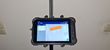
with the new LT800H RTK RUGGED Tablet Kit 8.1" by CHC NAV
Operating system: Android 12.0 GMS certified
CPU Advanced Octa-Core CPU 2.0 GHz
Memory RAM 6 GB, ROM 128 GB
Expansion Micro SD card, up to 512 GB
All satellite navigation systems (full constellation)
Display: Size 8.1 inches, touchscreen, resolution 1920 x1200
Brightness 600 cd/m2 anti-glare, excellent sunlight-readable screen,
Corning Gorilla Glass 3
Camera: Front 8 MP, rear 16 MP, flash integrated
Physical: Dust and water resistant IP67
Shock resistance 1.5 m drop on concrete
Li-ion battery 9000 mAh, for up to 12 hours of running time
APP: GNSS tool NTRIP client
Scope of delivery:
⦁ Tablet
⦁ Data cable
⦁ Li-ion battery
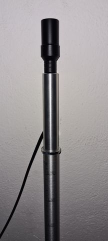
⦁ Helix spiral antenna
⦁ Power adapter
⦁ Stylus
⦁ Dual USB stick (USB-C+USB-A)
⦁ Helix antenna adapter for plumbing pole (to attach helix antenna to plumbing pole)
⦁ Antenna cable for helix antenna
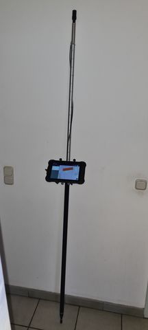
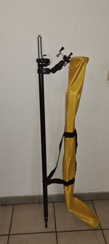
⦁ 2m telescopic plumbing pole with carrying case
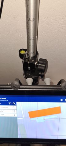
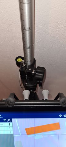
⦁ Compass and spirit level integrated in the plumbing pole
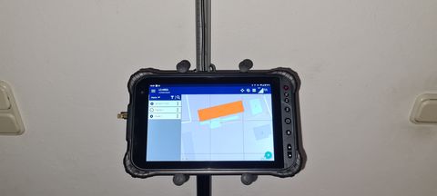
⦁ Tablet holder on the plumbing pole
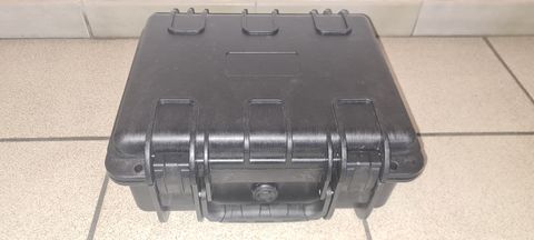
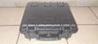
⦁ Hard case for antenna and accessories
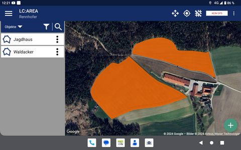
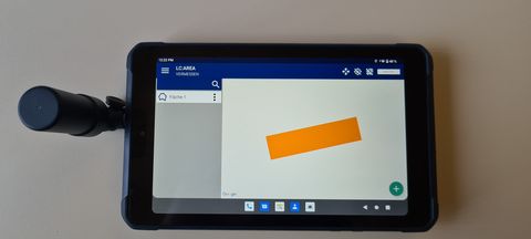
SURVEYING SOFTWARE LC:AREA - Professional
⦁ Measuring areas, lines, points
⦁ Measuring collection points
⦁ Digitizing areas, lines, points on the map
⦁ Finding areas, lines, points
⦁ Managing factual data for Objects
⦁ Management of objects in projects
⦁ Import / export of objects as shape or KML files
⦁ Export of field boundaries and lanes as ISOXML
⦁ Google standard, satellite and hybrid background maps
⦁ Management of several cadastral communities at the same time
Up to 5 cadastral communities with a cut-off date of October 1, 2023 are copied to the tablet or the LC-Area app at no additional cost. This makes it easy to search for boundary stones and there are no additional costs for purchasing survey data from the Federal Office of Metrology and Surveying.
Thanks to the ISOXML export option, the surveyed fields or lanes can be imported directly into the tractor's track guidance system using the supplied dual USB stick (USB-C + USB-A), meaning that additional software for post-processing on the PC is no longer required. This is currently an absolute unique selling point on the agricultural surveying market!
with the new LT800H RTK RUGGED Tablet Kit 8.1" by CHC NAV
Operating system: Android 12.0 GMS certified
CPU Advanced Octa-Core CPU 2.0 GHz
Memory RAM 6 GB, ROM 128 GB
Expansion Micro SD card, up to 512 GB
All satellite navigation systems (full constellation)
Display: Size 8.1 inches, touchscreen, resolution 1920 x1200
Brightness 600 cd/m2 anti-glare, excellent sunlight-readable screen,
Corning Gorilla Glass 3
Camera: Front 8 MP, rear 16 MP, flash integrated
Physical: Dust and water resistant IP67
Shock resistance 1.5 m drop on concrete
Li-ion battery 9000 mAh, for up to 12 hours of running time
APP: GNSS tool NTRIP client
Scope of delivery:
⦁ Tablet
⦁ Data cable
⦁ Li-ion battery
⦁ Helix spiral antenna
⦁ Power adapter
⦁ Stylus
⦁ Dual USB stick (USB-C+USB-A)
⦁ Helix antenna adapter for plumbing pole (to attach helix antenna to plumbing pole)
⦁ Antenna cable for helix antenna
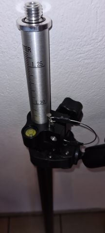
⦁ 2m telescopic plumbing pole with carrying case
⦁ Compass and spirit level integrated in the plumbing pole
⦁ Tablet holder on the plumbing pole
⦁ Hard case for antenna and accessories
SURVEYING SOFTWARE LC:AREA - Professional
⦁ Measuring areas, lines, points
⦁ Measuring collection points
⦁ Digitizing areas, lines, points on the map
⦁ Finding areas, lines, points
⦁ Managing factual data for Objects
⦁ Management of objects in projects
⦁ Import / export of objects as shape or KML files
⦁ Export of field boundaries and lanes as ISOXML
⦁ Google standard, satellite and hybrid background maps
⦁ Management of several cadastral communities at the same time
Up to 5 cadastral communities with a cut-off date of October 1, 2023 are copied to the tablet or the LC-Area app at no additional cost. This makes it easy to search for boundary stones and there are no additional costs for purchasing survey data from the Federal Office of Metrology and Surveying.
Thanks to the ISOXML export option, the surveyed fields or lanes can be imported directly into the tractor's track guidance system using the supplied dual USB stick (USB-C + USB-A), meaning that additional software for post-processing on the PC is no longer required. This is currently an absolute unique selling point on the agricultural surveying market!
Vermessungsset "Professional" für hochgenaue RTK Feldvermessung
mit dem neuen LT800H RTK RUGGED Tablet Kit 8,1" von CHC NAV
Betriebssystem: Android 12.0 GMS-zertifiziert
CPU Fortschrittliche Octa-Core-CPU 2.0 GHz
Arbeitsspeicher RAM 6 GB, ROM 128 GB
Erweiterung Micro SD-Karte, bis zu 512 GB
Alle Satellitennavigationssysteme (full constellation)
Anzeige: Größe 8,1 Zoll, Touchscreen, Auflösung 1920 x1200
Helligkeit 600 cd/m2 blendfrei, hervorragend bei Sonnenlicht ablesbarer Bildschirm,
Corning Gorilla Glas 3
Kamera: Vorderseite 8 MP, Rückseite 16 MP, Blitzlicht Integriert
Physikalisch: Staub- und wassergeschützt IP67
Stoßfestigkeit 1,5 m Fall auf Beton
Li-Ionen-Akku 9000 mAh, für bis zu 12h Laufzeit
APP: GNSS-Tool NTRIP-Client
Lieferumfang:
⦁ Tablet
⦁ Datenkabel
⦁ Li-Ionen-Akku
⦁ Helix-Spiralantenne
⦁ Netzadapter
⦁ Eingabestift
⦁ Dual USB-Stick (USB-C+USB-A)
⦁ Helix-Antennenadapter für Lotstab (um Helixantenne am Lotstab zu befestigen)
⦁ Antennenkabel für Helix-Antenne
⦁ Lotstab 2m teleskopierbar mit Tragetasche
⦁ Kompass und Libelle integriert im Lot-Stab
⦁ Tablet-Halter am Lotstab
⦁ Hartschalenkoffer für Antenne und Zubehör
VERMESSUNGSSOFTWARE LC:AREA - Professional
⦁ Vermessen von Flächen, Linien, Punkten
⦁ Vermessen von Sammelpunkten
⦁ Digitalisieren von Flächen, Linien, Punkten auf der Karte
⦁ Finden von Flächen, Linien, Punkten
⦁ Verwaltung von Sachdaten zu Objekten
⦁ Verwaltung von Objekten in Projekten
⦁ Import / Export von Objekten als Shape- oder KML-Datei
⦁ Export von Feldgrenzen und Fahrspuren als ISOXML
⦁ Google Standard-, Satellit- und Hybrid-Hintergrundkarten
⦁ Verwaltung mehrere Katastralgemeinden gleichzeitig
Bis zu 5 Katastralgemeinden mit Stichtag 01.10.2023 werden ohne weitere Kosten auf das Tablet bzw. in die LC-Area App kopiert. Dadurch können Grenzsteine einfach gesucht werden und es fallen keine zusätzlichen Kosten für den Kauf von Vermessungsdaten beim Bundesamt für Eich- und Vermessungswesen an.
Durch die Möglichkeit des ISOXML Export können die vermessenen Felder oder auch Fahrspuren direkt mittels mitgelieferten Dual USB-Stick (USB-C+USB-A) ins Spurführungssystem am Traktor eingespielt werden, eine zusätzliche Software zur Nachbearbeitung am PC ist dadurch nicht mehr erforderlich. Dies ist derzeit ein absolutes Alleinstellungsmerkmal am Markt für landwirtschaftliche Vermessung!
Show original
New machine
Type:
CHCNAV RTK Felder Vermessungsstab Professional
PDF specifications
Add to favourits
Stefan Rennhofer
Show telephone number
Show telephone number

Address verified
Phone verified
Very good data quality
Phone verified
Very good data quality
MEMBER SINCE 2022
Precision Farming Technology and Networks GmbH
Werkgasse 6
3123 - Obritzberg
3123 - Obritzberg
More offers from this dealer
All ads of this dealer